Informed decision making for Fire Resiliency.
Leverage your LiDAR, Satellite and Remote sensing data to fit your objectives.
Experts in Wildfire Fuels Mapping
Fuel ID is designed to enable users without remote sensing analysis expertise to quickly produce vegetation fuel attribute mapping products, including Fire Behaviour Prediction (FBP) System fuel type classes and FBP–Next Generation (FBP-NG) fuel attribute maps, from remote sensing data at spatial resolutions as low as 1 m2.
Forsite in collaboration with Ember Research Services Ltd. has developed an automated pipeline generating fuel characteristics from LiDAR and satellite data. We’ve also crafted high-res (10m) Canadian Fire Behaviour Prediction (FBP) System fuel maps for Alberta, British Columbia, and Saskatchewan.
- We’ve developed LiDAR-derived models predicting 56 fuel characteristics, including canopy, midstory and surface fuels, and
- LiDAR/satellite indices to improving accuracy and resolution in Canadian FBP maps.
- Extensive user interviews shaped Fuel ID and demonstrated its usefulness for applications like hazard assessments, emergency operations and ecological restoration.
- We have enhanced mapping accuracy and fast fuel mapping updates, critical for wildfire decision-making. Following significant wildfires during the 2023 season, demand for timely FBP System maps is evident.
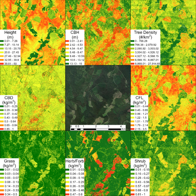
Wildfire fuel information generation within Fuel ID is categorized into two streams. The first is composed of LiDAR-derived canopy, midstory and surface fuel information that characterize wildfire fuels in a much more detailed and comprehensive way than the FBP System fuel types. Fuel characteristic models and their raster outputs have been derived across multiple areas of interest in British Columbia and Alberta, allowing users to access wall to wall information within these areas. A total of 56 different fuel characteristics were estimated encompassing a range of stand structure, canopy and surface fuel categories. As we continue to develop Fuel ID, the entire footprint of Canada will be available for users.
Furthermore, we are developing this component of Fuel ID to be dynamic in nature, allowing users to upload their LiDAR and/or field data into the application, which can be seamlessly integrated into the modeling structure, facilitating the derivation of these detailed fuel layers across new areas. Phase 2 of our product development will focus on this component – stay tuned for updates.
Contact us to access wildfire fuel characteristic mapping products for your area of interest.
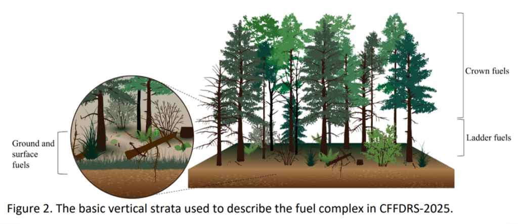
Prediction of fuel characteristics involved the selection of suitable areas of interest (AOIs) based on the availability of suitable LiDAR and high-quality field data. Regression models were developed to predict a large range of canopy, midstory and surface fuel characteristics in these AOIs. A total of 56 different fuel characteristics were estimated encompassing a range of stand structure, canopy and surface fuel categories. Accuracies (R2) among the stand structure and canopy fuel categories were generally over 0.5.
FBP map development used Sentinel-2 data, freely available LiDAR data and fuel typing algorithms (where available) to improve on both resolution and accuracy of existing provincial and national fuel type maps. Spectral indices of these characteristics based on Sentinel-2 and LiDAR data were calculated and then used to update FBP System fuel type maps in two ways: (1) directly updating existing maps by correlating spectral indices with fuel typing methods; and (2) update Vegetation Resource Inventory data and reproduce maps using fuel typing algorithm. WFG provides a process for updating and expanding best available FBP/Fuel base maps, with the best available data, where incorporating wide swaths of LiDAR presently available. Results shows the potential to significantly improve the quality and resolution of existing maps.
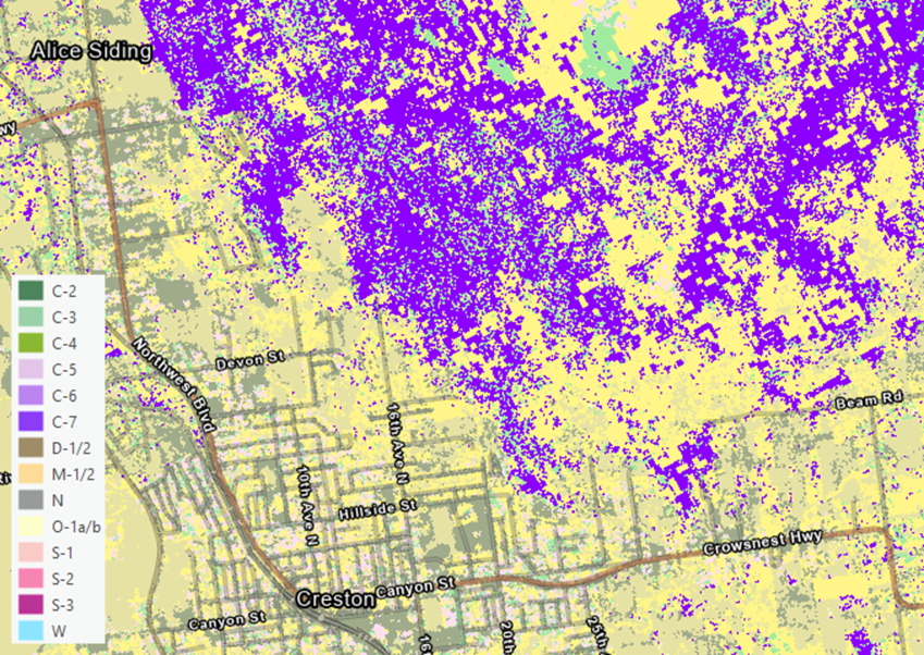
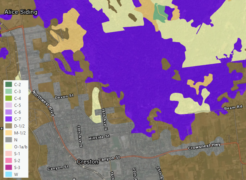
The second data stream is based on the FBP System fuel type classification system.
Using Fuel ID, FBP System fuel types have been derived from satellite imagery and LiDAR data in British Columbia (BC), Alberta (AB) and Saskatchewan (SK) at a higher spatial resolution (10 m) and accuracy than is currently available (250m and 30m). FBP map development used Sentinel-2 data, freely available LiDAR data and fuel typing algorithms (where available) to improve on both resolution and accuracy of existing provincial and national fuel type maps. Fuel ID provides a process for updating and expanding best available FBP/Fuel base maps, with the best available data, where incorporating wide swaths of LiDAR presently available.
Currently, data can be accessed by contacting Forsite. In the next phase of our development, these data layers will be continuously updated to support Fuel ID users, who will be able to access these layers and perform quick actions such as amending them to suit operational needs (e.g., incorporating back burning operations or current fire perimeters).
Contact us to access FBP System mapping products for your area of interest.
Interviews with potential users from across wildfire professions were conducted during our development process to ensure Fuel ID met the needs of users in Canada. Information gathered included potential uses of Fuel ID products in wildfire research, mitigation, and operations work. User feedback identified which fuel characteristics and FBP System data were most critical for wildfire mitigation requirements.
Thank you to all who provided their feedback. For further feedback and questions, please contact us.
Explore our Interactive High-Resolution Fuel mapping page →
If you are you interested to learn more about Forsite’s remote sensing capabilities, please look at our TreeID and Utilities Risk Assessment pages.
Joanna Wand
WILDFIRE RISK SPECIALIST
Acknowledgements
We extend our heartfelt thanks to our dedicated team and partners, with special mention to Innovative Solutions Canada (funding through High Resolution Forest Mapping grant). Data contributions from Forsite, University of British Columbia Tree Ring Lab and partners, BC Ministry of Forests Forest Analysis and Inventory Branch, Ontario Forest Resources Inventory, and Jeremy Arkin PhD have been instrumental.